Free Courses Sale ends Soon, Get It Now


NARMADA RIVER

22nd November, 2023

NARMADA RIVER

Disclaimer: Copyright infringement not intended.

Context

  • A division bench of the MP High Court has given the state administration time to provide in court the rules for construction in the vicinity of the river Narmada in the state's urban and rural districts.

About Narmada River

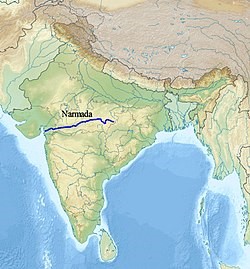
  • The Narmada is peninsular India's greatest west-flowing river.
  • The Narmada River runs west through a rift valley formed by the Vindhya Range to the north and the Satpura Range to the south.
  • It rises at an elevation of roughly 1057 meters from the Maikala range near Amarkantak in Madhya Pradesh.
  • The Narmada basin spans the states of Madhya Pradesh, Gujarat, Maharashtra, and Chhattisgarh and has an area of one lakh square kilometers.
  • It is flanked on the north by the Vindhyas, on the east by the Maikala range, on the south by the Satpuras, and on the west by the Arabian Sea.
  • It runs 1,310 kilometers from its headwaters in Amarkantak to its estuary in the Gulf of Khambhat.
  • The higher sections of the basin are mountainous, but the lower-middle reaches are vast and fertile, making them ideal for farming.
  • Jabalpur is the basin's sole significant urban center.
  • Near Jabalpur, the river cascades (a small waterfall, especially one in a sequence) 15 metres into a canyon to produce the Dhuan Dhar (Cloud of Mist) Falls. Because the gorge is made of marble, it is also known as the Marble Rocks.
  • It creates two 12-metre-high waterfalls at Mandhar and Dardi.
  • Near Maheshwar, the river drops from another modest 8-meter-high waterfall known as the Sahastradhara Falls.
  • The Narmada estuary has various islands, the biggest of which is Aliabet.
  • The Narmada may be navigated for up to 112 kilometers from its mouth.
  • Indira Sagar, Sardar Sarovar, Omkareshwar, Bargi, and Maheshwar are the basin's largest hydropower projects.

Tributaries:

  • The predominant tributaries from the right are – Hiran, Tendori, Barna, Kolar, Man, Uri, Hatni, and Orsang.
  • The predominant left tributaries are – Burner, Banjar, Sher, Shakkar, Dudhi, Tawa, Ganjal, Chhota Tawa, Kundi, Goi, and Karjan.

Dams:

  • The Major dams on the river include Omkareshwar and Maheshwar dams.

Narmada Basin

  • The Narmada basin has an area of 98,796 square kilometers, accounting for roughly 3% of the country's overall geographical area.
  • The Vindhyas borders the basin on the north, the Maikala range on the east, the Satpuras on the south, and the Arabian Sea on the west.
  • The basin, located at the northernmost tip of the Deccan plateau, encompasses considerable regions in the states of Madhya Pradesh and Gujarat, as well as a minor area in Maharashtra and Chhattisgarh.
  • The mountainous regions are in the basin's higher reaches, while the lower middle reaches are broad and fertile lands well suited for farming.

PRACTICE QUESTION

The Narmada River flows to the west, while most other large peninsular rivers flow to the east. Why?

  1. It occupies a linear rift valley.
  2. It flows between the Vindhyas and the Satpuras.
  3. The land slopes to the west from Central India.

Select the correct answer using the codes given below:

  1. A) 1 only
  2. B) 2 and 3
  3. C) 1 and 3
  4. D) None

Answer: A